For our camping trip last summer (the summer of 1998), we tried something a bit more challenging. Up to this time we have stayed in provincial parks and, even though we were staying in tents, hot showers, flush toilets, and restaurant food were only steps away.
The new location was along the Mattawa River at Bouillon Lake (A).
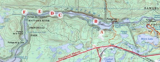
In the above map, north is at the top and the letters A through F are interest points along the way (with accompanying pictures and text).
The Mattawa River flows roughly west to east from Trout Lake (just east of North Bay) and ends at the Ottawa River. North Bay is located about 330 km north of Toronto. North Bay is about 21 km (as the crow flies) from the left edge of the map.
While the river is only a few 10's of kilemeters long, it served as an important link in the early fur-trading days. It was the network of rivers that opened up the north. "Voyageurs" would bring their canoes, laden with fur, along the river in the spring (when the water levels were high and fewer portages were required). Where the Mattawa River meets the Ottawa, they could sell their furs to the Hudson's Bay Company or comtinue down the Ottawa River to Ottawa (Canada's capital) or Montreal.
If you want to learn more about the area, visit the websites of North Bay and Mattawa. A list of the portages and other park information can be found at Mattawa River Provincial Park site.
(previous) What I did last summer...
(next) Not exactly voyageurs