
Pinery's Nipissing Nature Trail is one of the most scenic trails in the park. This challenging 2.0 km trail leads you through some of the oldest and largest sand dunes in the park. The trail winds up and down several dunes extending up to 25 to 35 m above Lake Huron water levels. These dunes have been built and moved by wind for the past several hundred years. An elevated lookout platform built on top of one of the highest dune crest provides an excellent view of most of the park, Lake Huron, and adjacent farmland. Also, observe the dramatic regrowth of plant life that has occurred after a controlled fire swept through the oak savannah in 1993.
The origin of the word Nipissing refers to a native American tribe who lived along the lake which bears their name, Lake Nipissing. They were referred to as Bissiriniens, Nepissirians, Nepissings, Nipissiriniens, and Nipistingues to the early French explorers and missionaries and as Askikwanehronans to their Huron allies. All of these names translate to mean "people of the little water," a reference to their main location on Lake Nipissing -- a small lake when compared to the Lake of the Hurons.
The Nipissing Indians are a branch of the Ojibway Tribal Organization, part of the Algonquin linguistic group, that dominated in the eastern woodlands of North America. Most of their villages were found on the north shore of Lake Nipissing just east of Lake Huron's Georgian Bay. The Nipissing occupied the important area between the Ottawa and French Rivers which linked Lake Huron to the St. Lawrence Seaway.
The Nipissing were too far north to rely on agriculture so they became hunters and gatherers. The family hunting grounds formed the basis of their socio economic organization and intruders into the family hunting area were liable to be put to death. Although some of the neighbouring tribes were said to have feared the Nipissings for their sorcery, they were active in trade for a long time before the arrival of the Europeans.
The word Nipissing is currently used by geologists to refer to a high water-level phase within the Great Lakes between approximately 4,000 to 6,000 years ago. Water levels were so high that Lakes Michigan, Huron, and Superior were considered to be one large lake. This large lake is referred to as "glacial" or "ancestral" Lake Nipissing to avoid confusion with the present-day Lake Nipissing up near North Bay, Ontario.
The Nipissing Nature Trail is built on top of several large sand dunes. Underneath these dunes are ancient shorelines of sand and gravel dating back as far as 4,000 to 6,000 years before present. Approximately 5,000 to 6,000 years ago most of Pinery Provincial Park was under water. Lake Huron water levels were 6 to 8 m above current lake levels and advanced to somewhere around the southeastern limit of the park, along Highway 21.
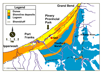
A barrier consisting of sand and gravel prevented the high water levels from advancing further inland where the elevation of the land surface was low. This barrier seems to extend in an arc all the way from south of Port Franks to the Grand Bend area underneath the high dunes.
In the low-lying area landward (southeast) of the barrier, a lagoon formed. High lake levels would have caused the lagoon to flood, forming shallow ponds that allowed true aquatic plants to survive, and deposited predominantly silt and clay. Lowering lake levels would have allowed organics and peat to accumulate in the saturated, low-lying areas of the lagoon. If you were to dig down into the lagoon today you would find thick sequences of silt and clay with organic sediments consisting of aquatic vegetation and remnants of freshwater, shallow-water organisms such as molluscs (clams).
As lake levels fell from the Nipissing high water-level phase to the present, several sand and gravel shorelines were created lakeward of the barrier. As the beaches were exposed sand was mobilized by the wind and blown into dunes. Since wind can only carry a narrow range of grain sizes, the sediment has to be first, available and second, be around long enough to build into dunes.
Wind transports sand primarily by skipping and bumping grains of sand across the ground surface. If a sand grain lands in an open area rather than a vegetated area it is more likely to continue skipping, bumping into another sand grain and initiate it to move, and/or becoming mobile by the wind in the near future. Therefore, dunes that become vegetated become more stable and do not migrate or move.
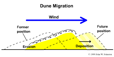
Dune migration is shown to the right. Sand grains bump and skip up to and over the crest of a dune where they are out of the wind's path. Grains then pile up and eventually slide down the downwind slope as it becomes too steep. This process repeats itself as long as the wind is strong enough to carry the sand grains and/or the grains aren't protected from the wind (ie. vegetation).
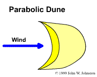
Several of the dunes in Pinery Provincial Park have been building and moving for hundreds of years. The oldest and largest dunes are located near the southeastern part of the park in the Nipissing Nature Trail area and extending along Highway 21. These dunes are some of the largest dunes in Ontario. Because of their arcuate shape, they are called parabolic dunes. A typical parabolic dune has a parabola-shaped central curve advancing downwind with two arms extending upwind on either side. The arms are commonly stabilized by vegetation and occur some distance from the beach.
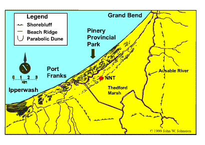
Dune crests were sketched from air photos and are shown in the picture to the right. Many of the strait lines near Ipperwash are small dunes, 1 to 2 m high which mimic the ancient shorelines they cover up. The curved lines near Pinery Provincial Park represent larger, more developed dunes. Measuring the orientation of the center of several parabolic dunes with respect to their arms indicates the wind direction during dune formation. The average orientation measured for several parabolic dunes was 307º. This indicates the predominent wind orientation during dune formation was from the northwest to the southeast.