The Roman Empire
The Roman Empire is central to the early Christian story. Yes, even in these early centuries, the Church did find its way to Armenia and India and Persia and China and Ireland elsewhere, but the numbers and proportional strength of Christians outside the Roman Empire were much smaller. So the Church's centre of gravity in the 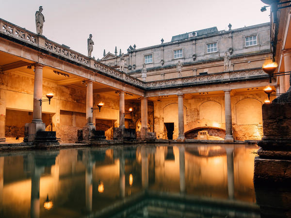 first several centuries remained the Roman Empire, and that's the geographical region of early Christianity that we know most about.
Also, pedagogically, it's useful to begin with a fairly generalized overview, even if at a more advanced level you'll find a great many past realities that don't fit it — and may well be more interesting and enlightening.
The Roman Empire was a huge jurisdiction stretching from Spain to Syria. It comprised a great number of peoples and nations, cultures and religions and languages. The imperial authorities generally allowed these peoples and nations to maintain their own languages and customs, but they also exported the Roman "brand" into cities across the Empire by establishing arenas, amphitheatres, baths, colonnades, aqueducts, and so on, in a Roman architectural style. In an important way, the Roman Empire became a model for the Church. The Church, too, came to see itself as a catholic or universal power containing a great number of peoples and nations.
Pictured here are the Roman baths that you can still visit in Bath, England. Baths were community centres, and often included libraries.
Roman ways influenced the early Church in many ways, although, in the first three centuries, as a result of occasional persecutions of Christians by the government, the Church demonstrated a strong counter-cultural element as well. In the fourth century, for better or worse, Christianity became the main Imperial religion. At that point, the fortunes of the Empire and the fortunes of the Church came to be intimately connected in political, economic,and social ways. For instance, doctrinal debates became inseparable from the politics of Empire and national identities, as we'll see later on. Not all Christians appreciated what could feel like attempts to co-opt them into the political status quo, and found ways to resist.
Why study geography?
1. One way to organize the story of early Christianity is by its geographical expansion. (This is an approach taken by the "Acts of the Apostles" in the New Testament.) A knowledge of geography and place-names helps us understand the story. (For one simple map of the early spread of Christianity, follow this link.)
2, The Christian Gospel is always proclaimed and lived in a specific cultural context, and it can't be identified with any one specific historical culture. So when we study the early Church, we'll find that Christianity looks different among different peoples. Geography helps us identify different peoples and therefore different inculturations of Christianity.
3. It's simply easy to get a mental picture of the historical episodes, trends, influences, and personal relationships if we know some of their geography.
A general map of the Roman Empire
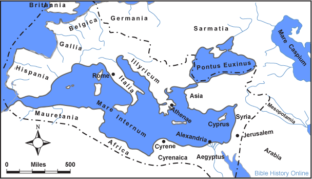
(This map is freely distributed from http://www.bible-history.com/maps/roman_empire.html.)
This map shows the general geographical names of areas in and around the Roman Empire.
Note that the Mediterranean Sea ("Mare Internum" above) is the central geographical reality on the map. "Mediterranean" means "in the middle of the world," which is no doubt how it appeared to people in the Roman Empire. The main way to get around the Roman Empire was by ship on the Mediterranean and its associated seas (but if you were a sailor you wouldn't want to be too far from sight of land). Thus it united the diverse and far-flung geographical units of the Mediterranean World. Because of dominant winds, sailing from west to east, and from north to south, was usually quicker than sailing in the other directions.
All the Mediterranean lands, being within the same range of latitude and sharing the common sea, had something of a common climate, and therefore something of a common economy and a common diet. The Biblical landscape of cities, towns, and villages, hills and plains, deserts and sea, olives and figs and vines, sheep and goats, was easily understood all around the Mediterranean world, in a way that it might not have been so easily understood in Hudson's Bay, the Indian Ocean, or the South Pacific.
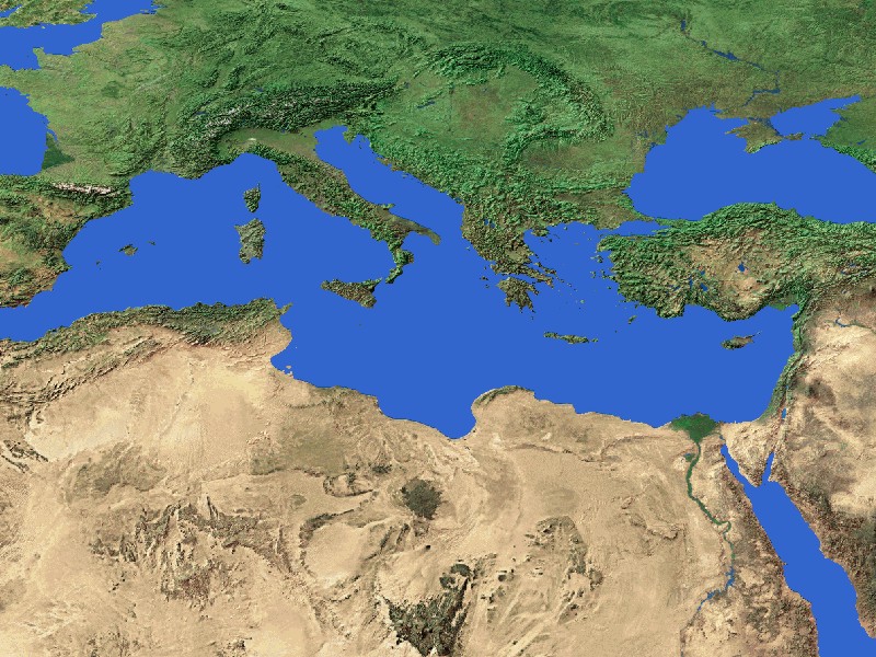
The Mediterranean Sea unites three continents. They are Europe (to the north), Asia (to the east), and Africa (to the south).
Take the link to the image of the Mediterranean world from a satellite's point of view. Most of north Africa and west Asia are desert, except for some sections along the coast, and along the Nile River Valley. Thus desert separates north Africa from the rest of Africa, and the middle East from central Asia. Mountains separate the Mediterranean coast of Europe from northern Europe, and the coast of Asia Minor from central Asia. Geographically, then, the Mediterranean world was somewhat turned in on itself.
Latin West, Greek East
This image is distributed under Creative Commons.
"Hellenization": In the eastern Mediterranean, in the wake of territorial conquests under Alexander the Great (d. 323 BCE), Greek became the common language, facilitating commerce for an area of many diverse languages.
"Romanization": In the western Mediterranean, in the wake of territorial conquests under the Romans, beginning in Italy in the 300s BC and expanding over the following centuries, Latin became the common language for an area of many diverse languages. The Romans conquered the eastern Mediterranean, too, but Greek continued in common use there. (For a map of the early expansion of Roman territory, follow this link to a University of Utah website.)
- (The terms "Hellenization" and "Romanization" have become problematized by recent generations of historians. Do they describe real processes? To some extent, they may be fictions promoted by the ancient apologists of empire who wanted to demonstrate and legitimate the success of the conquerors. On the ground, there was certainly considerable popular resistance to Empire, and a considerable continuity of Indigenous cultures. Nevertheless, for our purposes, it's useful to keep in mind that Latin functioned as a common language in the culturally diverse West, and Greek functioned as a common language in the culturally diverse East.)
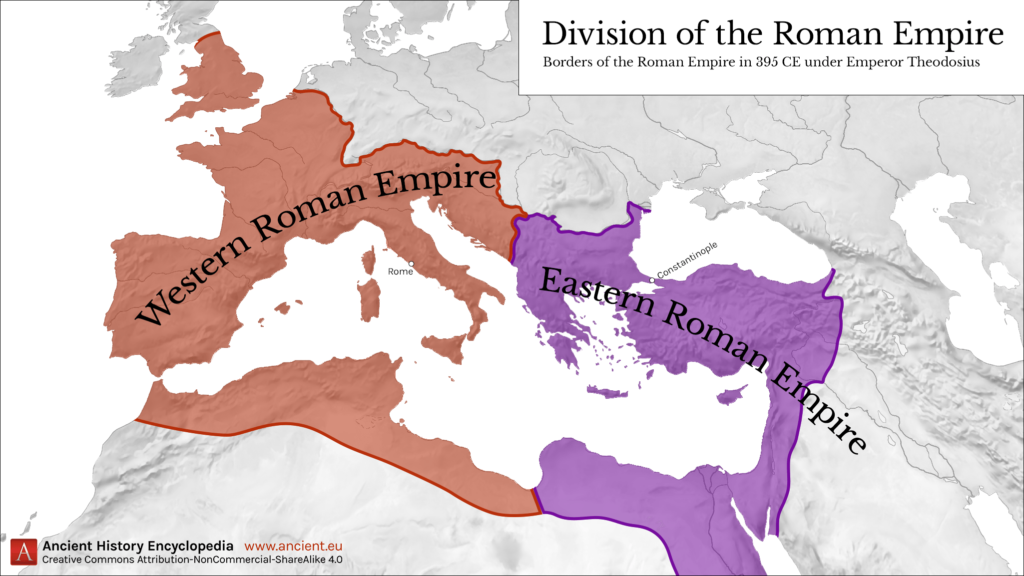
Before 285 the Roman Empire was governed as a unity, but in 285 CE it was politically divided into East and West for purposes of governance and administration. Emperor Constantine reunified the Empire in 324; after his death, the Empire was partitioned again, then reunified, and finally partitioned again in 395. In 476 the last western Roman Empire abdicated, and in theory the Empire was reunified again, although in practice few Eastern Emperors were able to maintain their authority in the West.
This history of linguistic, political, and cultural division helps explain the origins of the division we have today between western Christianity, on the one hand, and Eastern and Oriental Orthodox Christianity, on the other.